


4,1 km | 6,9 km-effort


Usuario


Aplicación GPS de excursión GRATIS
 SityTrail
IGN / Institutos geográficos
SityTrail World
El mundo es suyo
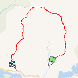
Ruta Senderismo de 13,7 km a descubrir en Desconocido, County Galway, Conamara Municipal District. Esta ruta ha sido propuesta por heb.
This is a beautiful and challenging route, considered by many to be one of the finest mountain walks in Ireland. Glencoaghan is a south-facing valley in the Twelve Bens, Connemara, Co Galway. The valley itself is low-lying and wet underfoot, but is surrounded by steep-sided mountains of mainly dry and rocky terrain (quartzite). The walk traverses these mountains, which comprise the majority of the highest peaks in the Twelve Bens, but excludes the very highest, Benbaun. Six summits in all are crossed, but others can be added if you're feeling particularly energetic. Difficulties The weather in Connemara is unpredictable and often inclement. It's not unusual for these peaks to be shrouded in cloud while the surrounding countryside enjoys fine weather. You will occasionally come across paths; however, many of these are nothing more than sheep tracks and should not be relied upon to guide you in the right direction. Carrying a map and compass and being able to navigate on difficult terrain in low visibility is essential. There are a number of rocky sections, particularly on the north ridge of Bengower, which may prove tricky for the inexperienced scrambler. That said, with reasonable fitness, appropriate clothing, a bit of luck (with the weather) and a careful approach to the difficulties, this walk can be enjoyed by most, reasonably experienced, hillwalkers. There are little or no opportunities to refill water bottles once on this route, so make sure you bring enough. You will meet few fellow walkers on these mountains; possibly none at all. This is one of the joys of walking and climbing in Connemara, but you will need to be self-sufficient and it is advisable to let someone know where you are going prior to departure, particularly if going alone. tomfahy
Senderismo